Showing 74 items matching murray river bridges
-
 Wodonga & District Historical Society Inc
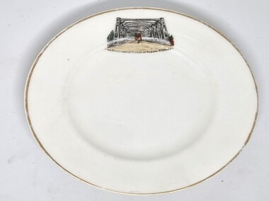
Souvenir - Souvenir Plate - Union Bridge, Albury, Hancock and Sons, c1930s
... Murray RIver bridges... border Murray RIver bridges Hancock and Sons ...This item is from a collection donated by descendants of John Francis Turner of Wodonga. It is one of many souvenirs produced to represent landmarks in the Albury-Wodonga district. The first punt across the Murray River at Albury was established by Robert Brown in 1843. In 1861 the first Union Bridge was built. It was demolished to make way for the second Union Bridge which opened in 1898. This second bridge closed and was eventually demolished after the third and existing bridge was opened in 1961. Hancock and Sons, Stoke on Trent - Sampson Hancock, a prominent Wesleyan Methodist, started potting in 1857. In 1891 he established the business of Sampson Hancock & Sons. Sampson died in 1900 and the business was continued by his three sons - Jabez, Harry and Arthur. In 1935 the business was in financial difficulty and was made bankrupt. It was restarted as S Hancock & Sons (Potters) Ltd. and moved to the Gordon Works, Hanley - which was renamed the Corona Works. The restarted company was not a success and it finally closed in 1937, having been put into receivership on 23rd March. This information helps to establish provenance of this plate.This item comes from a collection used by a prominent citizen of Wodonga. It is representative of a items produced to represent historic landmarks or features of the district.Fine China round plate with gilt edge and image of the Union Bridge, AlburyBeneath image: " THE BRIDGE OVER THE MURRAY AT ALBURY, NSWALESalbury souvenirs, union bridge albury, albury-wodonga border, murray river bridges -
 Rutherglen Historical Society
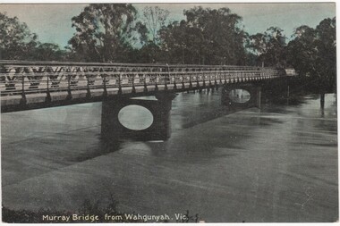
Postcard - Post card, McNicoll, Murray Bridge from Wahgunyah, Victoria
... . john foord bridge murray river bridges murray bridge McNicoll ...Post card photograph, black and white with some colour tinting.john foord bridge, murray river, bridges, murray bridge -
 Ballarat Tramway Museum
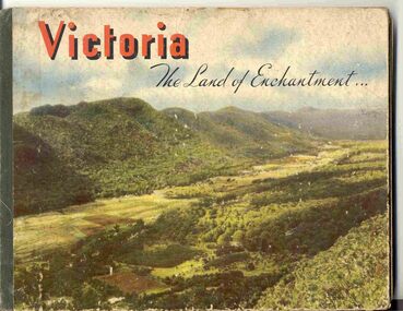
Book, Nu-Color-Vue Productions Pty Ltd, "Victoria The Land of Enchantment", c1950
... River Bridge, Bendigo Post Office, Melbourne Botanical Gardens... River Bridge, Bendigo Post Office, Melbourne Botanical Gardens ...Book with hardcovers, 48 pages titled "Victoria The Land of Enchantment". Sewn in three sections, with a green strip of cloth and self end papers and printed outer paper, sides glued onto board covers. Consists of 43 colour photographs (full and half page) with captions, detailed text, and two black and white photos printed in blue on end covers. Photos of Mt Buffalo, Gippsland lakes, Mornington Beach, Yarra River, Flinders St. station from the Yarra, Collins and Spring St (with two W2's - see image No. 2), Parliament House, Kiewa Hydro scheme, Eildon Weir, Swan Hill Murray River Bridge, Bendigo Post Office, Melbourne Botanical Gardens, Ballarat - Grenville and Sturt St (No. 22 - see image No. 3), Lorne, Yallourn Power Station, Hume Weir, Maroondah Weir, Great Ocean Road, Warrnambool, Portland Beach, A timber train (see image No. 4), Mildura, flax mills, Eastern Geelong and the Prime Ministers Ave, Ballarat. Produced by Nucolorvue Productions, c1950. See also Reg Item 2925 for the same photo of No. 22 and Reg Item 5354 for a postcard. Purchased via eBay site - see attached sheets and packing slip. Purchased 10/2/2005 for A$12.50 including postage, from Virginia Georgopoulos of West Brunswick. eBay sheets and envelope with worksheet file. Has Swains 123 Pitt St, Sydney sticker on bottom left hand corner page 2trams, tramways, ballarat, sturt st, grenville st, bogie trams, geelong, bendigo, melbourne -
![Scene Near the Buffalo Mountains / [by] Nicholas Caire, circa 1876](https://victoriancollections.net.au/media/collectors/550653872162f11fb04854aa/items/57826074d0cdd1176ce5bcc1/item-media/578260d1d0cdd1176ce5f61a/item-fit-380x285.jpg) Kew Historical Society Inc
Kew Historical Society IncPhotograph, Anglo-Australasian Photographic Company, Scene Near the Buffalo Mountains, c. 1876
... to the River Murray. The Bridge which is seen on the right... to the River Murray. The Bridge which is seen on the right ...Nicholas Caire was born on Guernsey in the Channel Islands in 1837. He arrived in Adelaide with his parents in about 1860. In 1867, following photographic journeys in Gippsland, he opened a studio in Adelaide. From 1870 to 1876 he lived and worked in Talbot in Central Victoria. In 1876 he purchased T. F. Chuck's studios in the Royal Arcade Melbourne. In 1885, following the introduction of dry plate photography, he began a series of landscape series, which were commercially successful. As a photographer, he travelled extensively through Victoria, photographing places few of his contemporaries had previously seen. He died in 1918. Reference: Jack Cato, 'Caire, Nicholas John (1837–1918)', Australian Dictionary of Biography.An original, rare photograph from the series 'Views of Victoria: General Series' by the photographer, Nicholas Caire (1837-1918). The series of 60 photographs that comprise the series was issued c. 1876 and reinforced a neo-Romantic view of the Australian landscape to which a growing nationalist movement would respond. Nicholas Caire was active as a photographer in Australia from 1858 until his death in 1918. His vision of the Australian bush and pioneer life had a counterpart in the works of Henry Lawson and other nationalist poets, authors and painters.‘Scene near the Buffalo Mountains’ : Views of Victoria (General Series) No.41 : Albumen silver photograph | Photo on card with Title and Description on reverse | Mounted 24 x 30 cm; Photo 12 x 17 cm.On Reverse: ‘This scene is taken from the banks of the Buckland River, which is about five miles distant from the Buffalo Mountains, as seen in the distance. These mountains are frequently covered with snow, in consequence of their great altitude. The Buckland River is a small tributary of the Ovens River, which flows through the Beechworth district, and eventually finds its way to the River Murray. The Bridge which is seen on the right of the picture forms the roadway which leads from the Buckland Camp to the Township of Bright.’nicholas caire (1837-1918), landscape photography -
 The Beechworth Burke Museum
Photograph, c.1927-1930
... residents of Bethanga across the Murray River before the Bethanga... across the Murray River before the Bethanga Bridge was built ...This image shows the Punt (a kind of small boat) that took residents of Bethanga across the Murray River before the Bethanga Bridge was built. Bethanga Bridge was built between 1927 and 1930, and was made a necessity by the building of the Hume Dam. The Hume Dam, formerly known as the Hume Weir, was in construction between 1919 and 1936, which swelled the Murray River into the floodplain to the East of the dam permanently, creating Lake Hume, and isolating the residents of Bethanga and nearby towns, for whom the trip all the way around the new lake to another river crossing was a massive undertaking. The person who wrote on the back of this card instead chose to cross the river on a boat until the Bethanga Bridge became available. Interestingly, partially submerged trees can be seen in the lake in the background of this photograph, illustrating that the dam had already begun to fill the floodplain even before the bridge was built. This photograph shows the methods the residents of Bethanga used while the Bethanga Bridge was being built. This record is associated with the Heritage Listed sites of the Hume Dam and the Bethanga Bridge, and shows the environment during the process of construction and the creation of Lake HumeSepia rectangular photograph printed on matte photographic paperReverse: 1997.3189 / 84 -19 -1 / This is the snap of the Punt. / Our only means of getting out / of Bethanga for the present / Until the bridge is completed / it is 2 miles above the junction / of the Mitta + Murray. It is / 1/2 a mile wide + runs across / the Murray into NSW / Kodak Print / bethanga, bethanga bridge, hume, hume dam, artificial lake, lake hume, hume weir, flood, floodplain, boat, punt, weir, pier, dock, transport, transportation -
 Marysville & District Historical Society
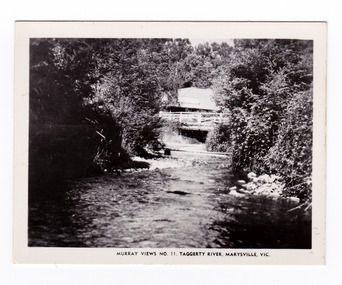
Photograph (item) - Black and white photograph, Murray Views, Murray Views No. 11. Taggerty River, Marysville, Vic, Post 1929
An early black and white photograph of the Steavenson River in Marysville, Victoria.An early black and white photograph of the Steavenson River in Marysville, Victoria. The Steavenson Falls is named after the Victorian Assistant Commissioner of Roads and Bridges, John Steavenson who arrived here in the early 1860s. This photograph was published by Murray Views in Gympie, Queensland, as a souvenir of Marysville.marysville, victoria, photograph, murray views, souvenir, steavenson river, john steavenson -
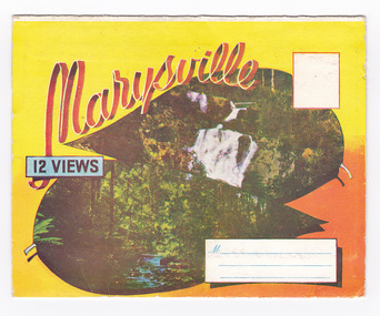 Marysville & District Historical Society
Postcard (item) - Colour photographs, Murray Views, Marysville 12 Views, 1950's
A fold out postcard of 12 colour photographs of scenes and landscapes in and around Marysville in Victoria.A fold out postcard 12 colour photographs of scenes and landscapes in and around Marysville in Victoria. These photographs were produced by Murray Views in Gympie, Queensland as a souvenir of Marysville.Marysville/ 12 VIEWS PRODUCED BY MURRAY VIEWS./ GYMPIE./ Q COPYRIGHT SAMUEL LEE & CO., PRINTERS. STEAVENSON'S FALLS, MARYSVILLE, VIC. TOURISTS AT MARYSVILLE, VIC. "FRUIT SALAD FARM", MARYSVILLE MAIN STREET, MARYSVILLE, VIC. ROAD SCENE, MARYSVILLE, VIC. THE CROSSWAYS, MARYSVILLE, VIC ROAD TO CUMBERLAND VALLEY, MARYSVILLE PANORAMA FROM BLACK SPUR, MARYSVILLE ROAD, MARYSVILLE, VIC. NICHOLL'S LOOKOUT, MARYSVILLE, VIC. TREE FERNS, MARYSVILLE, VIC. THE BRIDGE, MARYSVILLE, VIC.steavenson falls (image 1), tourists in marysville (image 2), taggerty river (image 3), fruit salad farm (image 4), main street marysville (image 5), road scene marysville (image 6), the crossways (image 7), cumberland valley (image 8), black spur (image 9), nicholl's lookout (image 10), tree ferns (image 11), bridge (image 12), marysville, victoria, postcard, souvenir, murray views -
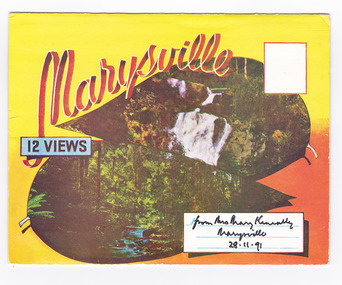 Marysville & District Historical Society
Postcard (item) - Colour photographs, Murray Views, Marysville 12 Views, 1950's
A fold out postcard of 12 colour photographs of scenes and landscapes in and around Marysville in Victoria.A fold out postcard 12 colour photographs of scenes and landscapes in and around Marysville in Victoria. These photographs were produced by Murray Views in Gympie, Queensland as a souvenir of Marysville.Marysville/ 12 VIEWS from Mrs Mary Keneally/ Marysville/ 28.11.91 PRODUCED BY MURRAY VIEWS./ GYMPIE./ Q COPYRIGHT SAMUEL LEE & CO., PRINTERS. STEAVENSON'S FALLS, MARYSVILLE, VIC. TOURISTS AT MARYSVILLE, VIC. "FRUIT SALAD FARM", MARYSVILLE MAIN STREET, MARYSVILLE, VIC. ROAD SCENE, MARYSVILLE, VIC. THE CROSSWAYS, MARYSVILLE, VIC ROAD TO CUMBERLAND VALLEY, MARYSVILLE PANORAMA FROM BLACK SPUR, MARYSVILLE ROAD, MARYSVILLE, VIC. NICHOLL'S LOOKOUT, MARYSVILLE, VIC. TREE FERNS, MARYSVILLE, VIC. THE BRIDGE, MARYSVILLE, VIC.steavenson falls (image 1), tourists in marysville (image 2), taggerty river (image 3), fruit salad farm (image 4), main street marysville (image 5), road scene marysville (image 6), the crossways (image 7), cumberland valley (image 8), black spur (image 9), nicholl's lookout (image 10), tree ferns (image 11), bridge (image 12), marysville, victoria, postcard, souvenir, murray views -
 Ringwood and District Historical Society
Book, Diane Baird, Digging Into History - Goldmining in Warrandyte, 2007
Information about early mining in Victoria's first gold field. Cover photographs: Front cover - Fossickers working below the water-wheen driven stamper battery located on the south side of the Yarra River upstream of the Warrandyte Bridge. Back cover - The Old Post Office, Warrandyte, in 1906, now the premises of the Warrandyte Historical Society Museum and Archive, 111 Yarra Street.Acknowledgements: Several members of the Warrandyte Historical Society were involved in the development of this publication. It was developed and written by Diane Baird; Murray Houghton and Ted Rotherham provided specialist historical details and further references; Jo Laurence and Shirley Rotherham collected and identified photographs; Brian Laurence prepared images for electronic format; and Richard Morton edited and formatted the text. The Society gratefully acknowledges the dedicated work of all its members who collect, preserve and share Warrandyte's history. In particular, the research by the late Bruce Bence and the dedicated work of the late Jo Laurence have been an invaluable contribution to the history of Warrandyte. -
 Port of Echuca
A black and white photograph, The Bridge Hotel, in 1896, showing Silky Oak trees, 1970's
... visitors to the town crossing the Murray River on his punt crossing... was situated just below the Bridge Hotel on the Murray River ...The Bridge Hotel was built by Henry Hopwood to house visitors to the town crossing the Murray River on his punt crossing, which was situated just below the Bridge Hotel on the Murray River. The accommodation was spacious and grand! In the right back corner of the photograph, the 'lantern' roof of the St Georges Hall can be seen. The street is level with the front entrance to the Hotel, which is very different to what it is today.The photograph shows hotel activities and accommodation in the late 19th Century.A black and white photograph of the Bridge Hotel taken from the Hopwood Gardens. The photograph shows four silky oak trees growing along the front of the building. There is an empty flag pole outside the front of the building. The right wing advertises billiards, whilst the left wing apparently was a bar.Written on the building can be seen the words; HOTEL and BILLIARDS. Written in pen on the back of the photograph are the words "Bridge Hotel. Probably 1896, showing Silky Oak trees.bridge hotel, henry hopwood, silky oak trees, lantern roof, st georges hotel -
 Port of Echuca
Black and white photograph, 20.04.1979
Relates to a series of 5 photos:P000094-P000098 of the front of the Bridge Hotel on the corner of Murray esplanade and Hopwood gardens. These photos taken in 1976, were before the Port Restoration Scheme renovated the hotel.The Bridge Hotel, Echuca is of historical and social significance in that it was originally built by Henry Hopwood, the founder of Echuca. Hopwood built the hotel to provide accommodation to people using his punts across the Campaspe and Murray rivers. The hotel was situated between the 2 punts. The hotel provided for a variety of levels of accommodation from grand rooms to very basic rooms. At the time of the photos the hotel was 120 years old and became an important part of the Port of Echuca tourism. Black and white photograph of the Bridge Hotel , taken from the corner of Murray esplanade and Hopwood gardens. A power pole pokes through the verandah roof of the eastern (left) wing. The eastern wing of the Bridge is clearly visible.On sign on the front verandah "unauthorised entry not permitted". On back of photo in pen :" 1"bridge hotel, echcua, port restoration scheme, bridge hotel restoration, echuca -
 Port of Echuca
Black and white photograph, Approx. 1980
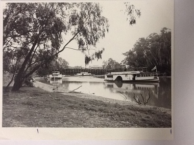
Information of construction of Pride of the Murray. Construction: Composite Tonnage: 71 gross 36 net Dimensions: L 82.4 ft B 15.5 ft D 4.4 Date of Registration: Melbourne 1870 no.88, 918 Built: Echuca, Vic. 1865 Owners: Permewan, Wights & co.This photo has Social and historical significance,depicting some of the boats and the wharf in the 1980's. It gives a very clear visual of the Port of Echuca wharf and the Echuca banks of the Murray with some of the beach visible. Black and white satin photograph of the starboard side of the P. S. Canberra sailing upstream on Murray river between the Port of Echuca wharf and the Echuca bridge. The Pride of the Murray (front on) can be seen further behind , on the left, with the Pevensey, which appears to be moored in front of the wharf in the background. On front of photo paddlesteamers are marked Canberra & Pride of the Murray. On back of the photo is marked in pencil: please return to Mrs H.Coulson, Port of Echuca, Box 35, Echuca.echuca wharf, p.s. canberra -
 Port of Echuca
Black and white photograph, Approx. 1975
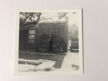
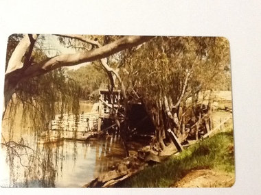
The old brick Murray River Sawmill office was demolished around 1975. This appears to be part of one of the office buildings associated with the sawmill, taken in shadow, with the building well back on the block, on the bridge side. There is a dirt driveway in front of the building and stacks of timber next to the chimney side of the building. Trees are visible behind these stacks of timber. Two stacks of timber (1x 4 blocks high, 1 X 3 blocks high) are in front of the building between the window and the chimney This relates to photographs P000106, P000105 Sawmills in the Echuca area were historically and socially significant being a large employer in the area. The Murray River sawmill was one of the biggest and longest operating sawmills in the area. Black and white photograph of an old Murray River Sawmill building with the chimney to the right and a door and window on the left. Two stacks of timber planks are against the wall between the window and the chimney. A dirt driveway is in front of the building with timber planks edging the driveway.On the reverse in pencil "Old M. R. S. Building well back on the block on the bridge side. Near old offices, also demolished about 1975??" Kodak, , in blue ink "0932"murray river sawmills, echuca, echuca, victoria, pullicino, j (unconfirmed) -
 Port of Echuca
A rectangular coloured photograph, 1970?
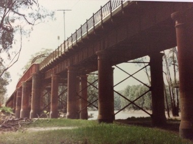
... the Murray River in the early 1970's. ... shows the Echuca Moama bridge crossing the Murray River ...This photograph shows the Echuca Moama bridge crossing the Murray River in the early 1970's. This photograph shows the Echuca Moama bridge in the early 1970's. It shows one of the rounded arches on the bridge. The rounded arches were the original arches and were at one stage replaced by square arches, but then replaced again by rounded arches.A rectangular coloured photograph of the Echuca Moama bridge taken from the Victorian bank, sometime in the early 1970's. One round bridge arch can be seen and a tall electricity pole can also be seen on top of the bridge. The vegetation on the Victorian bank is short and cropped. Some dead branches lie on the ground in the left foreground.There are none.echuca moama bridge, murray river, victorian bank -
 Port of Echuca
Colour Photograph, Approx.1979
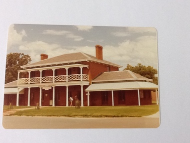
The Bridge Hotel was built by Henry Hopwood, founder of Echuca. The building was in disrepair until it was bought by the Port of Echuca and renovated to be turned into part of the Port of Echuca tourist exhibits and was leased out to be run as a restaurant.The Bridge Hotel is of historical and social significance to Echuca as it was built be Echuca's founder Henry Hopwood. The hotel was situated between the 2 rivers, Murray and Campaspe, where Hopwood ran his punt business, charging people and animals to cross the rivers. The hotel accommodated a variety of paying guest from wealthy squatters to salesmen and general workers. The building was purchased by the Port of Echuca to be part of the tourist attraction. It was extensively renovated to bring it back to its former glory. The Bridge hotel played an important role in the TV series "All the Rivers Run". Colour photograph of the Bridge Hotel, Echuca, after restorations (c.1979)On front of building : Bridge Hotel / Restaurant Printed on reverse:"This paper manufactured by Kodak"bridge hotel, echuca, port of echuca, echuca, victoria -history, henry hopwood -
 Port of Echuca
Colour photograph, Approx.1979
This photograph shows a punt (with a dingy tied to it ) moored to the wharf structure on the Murray river at Echuca. Punts were used to transport people and goods from one side of the river to the other.Punts were used to cross the Murray river at many spots before bridges were built. Henry Hopwood set up his initial business with punts across the Murray and Campaspe rivers, charging people, animals and vehicles to cross the rivers.Colour photograph of a punt tied to the port structure, seen through the foliage of gums on the river bank.On reverse:" This paper manufactured by Kodak"port of echuca, hopwood's punt, echuca, port of -
 Port of Echuca
Colour photograph, 1979
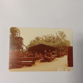
Discussed in book : Echuca: A centenary history by Susan Priestley, pp.21, 38, 45, 66, 114-123, 126, 174 R.J.Evans established this mill on the banks of the Murray River, Echuca in 1923 & it operated until 1980. The mill later became a tourist attraction, Red Gum Works, continuing to cut timber until it was taken over by The Port of Echuca as a display (Port of Echuca booklet, 2005 ed., p. 32)Sawmilling was a very important industry for Echuca. At its peak in Echuca in about 1877 there were between 1000-1500 men employed in the industry (Priestley, Susan. 1965, p.118). Red gum was sourced from the forests along the Murray river. It is a very strong timber suitable for bridge & wharf building, construction works as well as housing and especially for sleepers for the railways. Mills relied on government contracts especially for the sleepers. Colour photograph (post-card size) of red gum sawmill on the Port of Echcua. Photograph is taken looking north.Printed on reverse: "this paper manufactured by Kodak."echuca, port of echuca, sawmilling, evans, r. j., red gum works -
 Port of Echuca
Black and white photograph, Mid 20th Century
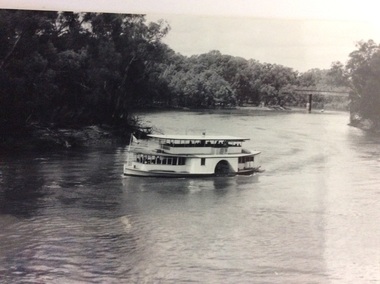
The P.S Canberra was built in 1912 at Goolwa South Australia by David Milne. It was built as a fishing vessel. It was originally a steam engine, reverted to diesel, but was returned to steam in 1995. It is currently owned by the Murray Steam Ship and Tourist Co. and has operated as a tourist vessel at Echuca Since 1967. (Ref Parsons, R "Ships of the Inland Rivers " p. 58)The P.S Canberra is significant as it has operated as a tourist vessel since 1967, and continues to do so. A black and white photograph of the P.S.Canberra coming downstream from the iron bridge at Echuca.On boat the words Canberra.p.s canberra, murray steam ship & tourist company -
 Port of Echuca
Black and white photograph
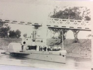
P.S Decoy was built in Scotland and reassembled in 1878 in Melbourne. It steamed to Goolwa, arriving in July 1878. It was used on the Darling River, and as a South Australian tug. In 1905 it sailed to Fremantle W.A for use as an excursion vessel. It was towed back to work on the inland river trade on the Darling -Murray system in 1909. It is now a house boat at Mannum. It's owner is Dick Bromhead.( Ref; Parsons, Ron. "Ships of the inland Rivers. P. 65.)The P.S Decoy is significant because it worked as a passenger vessel as well as a transport vessel. It was built in Scotland and reassembled in Melbourne. It was built to use coal, but when it started work on the inland rivers system it was converted to wood fuel.Two black and white photographs ( P000385.1 is missing) of the P.S Decoy passing under a bridge. There are high banks behind the boat and there are nine people on board.On the boat is the word 'Decoy' written on the bow and under the wheelhouse.p.s decoy, darling river, murray river, goolwa, mannum, passenger vessel, bromhead, dick -
 Port of Echuca
Black and white photograph
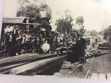
Macintosh's sawmill was on the banks of the Murray River in Echuca east where the Banyule State forest is now located. A tramway ran out to it from the main rail line near the iron bridge. Macintoshes Sawmill was one of the largest in the area. (Ref. Clare Jackson. )Macintoshes sawmill was set up by James Macintosh in 1868 in Echuca East. His sawmill prospered and in 1878 was "equal to five normal sawmills" (Ref; Coulson, Helen, "Echuca Moama On the Murray." P.158) He also owned 2 paddle steamers and 8 barges. The Macintosh Family contributed substantially to the development of Echuca East, but by 1901 the Family was in severe debt and were forced to sell the sawmill to the Nicholas Family.A black and white photograph of a large group of men outside a sawmill, reputed to be Macintoshes Sawmill in Echuca East.On the back of the photograph written in pencil are the words "Believed to be workmen at McIntosh's mill (Charlie Dowell says)macintosh's sawmill, sawmill industry, echuca east, banyule state forest, macintosh james, dowell, charlie, logging industry, jackson, clare -
 Tatura Irrigation & Wartime Camps Museum
Photograph, Alan Whiting, 1924
Taken for the Victorian State Rivers and Water Supply Commission.Mounted medium sized black and white photograph. Waranga Basin inlet structure of concrete across water / Man on horseback centre of bridge / Rock wall bottom left corner.irrigation, victorian state rivers and water supply commission, waranga basin -
Tatura Irrigation & Wartime Camps Museum
Photograph, 19/12/1946
Taken by photographer for State Rivers and Water Supply Commission.Medium sized black and white photograph. Waranga Reservoir main outlet - Western main channel looking downstream to Waranga. Concrete bridges and control structure join earthen banks of channel. Windmill mid-left of picture.goulburn weir, victorian state rivers and supply commission -
Tatura Irrigation & Wartime Camps Museum
Photograph, 19/12/1946
Taken by photographer for State Rivers and Water Supply Commission.Medium sized black and white photograph. Centre picture: Horse drawn scoops dig clay from the borrow pit, and the central horse-drawn cart moves under the bridge to collect clay through an opening in the roof for transport to the embankment.goulburn weir, victorian state rivers and supply commission -
Tatura Irrigation & Wartime Camps Museum
Photograph, Cattanach Canal, 1957
Taken by the photographer for Victoria State Rivers and Water Supply Commission.Large sepia photograph - Construction equipment middle foreground, two bridges, truck crossing second bridge, trees, flat paddock, scattered trees, man working on nearer concrete bridge support.Below photo: "Cattanach Canal / Rail and Highway Bridges near Murchison"irrigation, victoria state rivers and water supply commission, cattanach canal, bridges -
Tatura Irrigation & Wartime Camps Museum
Folder, State Rivers & Water Supply Commission Construction and District Branches, 1950
Contains various publications on procedures for Water Commission constructions and irrigation methods and some photographs of assembling of a bridgeBlack and white marbled cover,metal leverwater, documents, phamphlets -
 Wonthaggi & District Historical Society
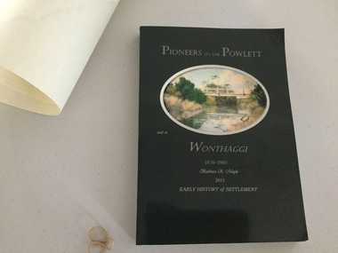
Book and Map, Barbara Moyle, Pioneers on tthe Powlett and at Wonthaggi 1878-1910, 2015
Book - families social histories, maps, photograps Map - block numbers town names physical / geographical featuresFarming and social history of pioneers of the Powlett River are prior to the establishment of the State Coal Mine at Wonthaggi. Significant land marks, buildings and photographs are included. Dark green cover with oval artists impression of Powlett river and bridge Associated map which covers the parishes plus key places of interestlPioneers on the Powlett and at Wonthaggi 1878-1910 Barbara R Moyle 2015 Early History of Settlement Map - Parish names, significant sitesfarming, pioneers of wonthaggi and district, wonthaggi families -
![The Punt, Echuca / [by] Nicholas Caire, circa 1876](https://victoriancollections.net.au/media/collectors/550653872162f11fb04854aa/items/57825721d0cdd1176ce1789a/item-media/57825765d0cdd1176ce19829/item-fit-380x285.jpg) Kew Historical Society Inc
Kew Historical Society IncPhotograph, Anglo-Australasian Photographic Company, The Punt, Echuca, c. 1876
Nicholas Caire was born on Guernsey in the Channel Islands in 1837. He arrived in Adelaide with his parents in about 1860. In 1867, following photographic journeys in Gippsland, he opened a studio in Adelaide. From 1870 to 1876 he lived and worked in Talbot in Central Victoria. In 1876 he purchased T. F. Chuck's studios in the Royal Arcade Melbourne. In 1885, following the introduction of dry plate photography, he began a series of landscape series, which were commercially successful. As a photographer, he travelled extensively through Victoria, photographing places few of his contemporaries had previously seen. He died in 1918. Reference: Jack Cato, 'Caire, Nicholas John (1837–1918)', Australian Dictionary of Biography.An original, rare photograph from the series 'Views of Victoria: General Series' by the photographer, Nicholas Caire (1837-1918). The series of 60 photographs that comprise the series was issued c. 1876 and reinforced a neo-Romantic view of the Australian landscape to which a growing nationalist movement would respond. Nicholas Caire was active as a photographer in Australia from 1858 until his death in 1918. His vision of the Australian bush and pioneer life had a counterpart in the works of Henry Lawson and other nationalist poets, authors and painters.Views of Victoria (General Series) No.34; ‘The Punt, Echuca’; Albumen silver photograph | Photo on card with Title and Description on reverse | Mounted 24 x 30 cm; Photo 12 x 17 cm.On Reverse: ‘The subject of this illustration is the principal crossing-place on the River Murray at Echuca, as regards the ordinary road traffic from the district of Riverina, New South Wales. After the periodical floods, the Punt is found to be insufficient for the large traffic; but this inconvenience will not be found to occur again to any great extent, as the new Railway Bridge from Moama will considerably lessen the road traffic through the Township of Echuca.’nicholas caire (1837-1918), echuca (vic), landscape photography -
 Orbost & District Historical Society
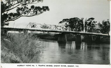
black and white photograph, Murray Studio, Murray Views, 1934
... printed - Murray Views No.4 Traffic Bridge , Snowy River, Orbost ...After the flood damage of 1934, the bridge was repaired with a new section in the middle. This bridge remained largely unchanged until its final demolition in 1975 after construction of the new concrete bridge and Orbost by-pass which exists today. This photograph is one of a collection of photographs produced by Murray Views, Gympie. It features eight scenic b/w photographic prints of Orbost and surrounding tourist areas.Photographs like these allowed tourists to send many images of their holiday destination or hometown in the one small package. Fred Murray opened Murray Studios in Gympie in 1906. The postcard and souvenir production side of the business initially covered Gympie and surrounding regions, but Murray expanded the business to include North Queensland, New South Wales and even Adelaide. It was opened under a separate name, Murray Views, in 1929. In 1945 the business was taken over by Murray’s nephews who began postcard folder production. This is a pictorial record of an early bridge across the Snowy River at Orbost.A black / white photograph / postcard of the Snowy River Bridge at Orbost.on front bottom printed - Murray Views No.4 Traffic Bridge , Snowy River, Orbost, Vic.orbost-snowy-river-bridge -
 Eltham District Historical Society Inc
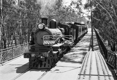
Photograph, VR Commissioner's Special train, steam locomotive D3-639 crossing the Echuca-Moama Road Rail Bridge over the Murray River from Moama, NSW to Echuca, Victoria, 1962
... crossing the Echuca-Moama Road Rail Bridge over the Murray River... crossing the Echuca-Moama Road Rail Bridge over the Murray River... Bridge over the Murray River from Moama, NSW to Echuca, Victoria ...VR Commissioner's Special train, steam locomotive D3-639 crossing the Echuca-Moama Road Rail Bridge over the Murray River from Moama, NSW to Echuca, Victoria. Commissioner Edgar Henry Brownbill on footplate, 1962. Commissioner Edgar Henry Brownbill was in office 1957 to 1967. George Coop advises - "The train on the Eltham/Moama bridge is actually the Commissioner’s Special on one of its inspection tours of the VR rail system. This was a very grand special train with accommodation for the Commissioner and staff in carriages also used once for the Royal Train and other State purposes. You can just see the Commissioner of the day, dressed in his suit and wearing engine drivers gloves, standing in the loco cab doorway. A good ‘hands on’ impression is created amongst local staff if can be seen that the boss is no ‘desk jockjey’. The observation car on the back was originally made for the ’Spirit of Progress’. I climbed up onto the bridge iron plate work to get this view. It was safe enough as the cantilevered pedestrian walkway was still on the east side at the time." "I was resident in Echuca from Jan. ’59 to approx. May ’64. At that time the single Echuca/Moama bridge was a combined road/rail bridge. The rail gauge was 5’3” and still is, I believe, on the new bridge that sits just upstream of the old one. This rail line into NSW has always been 5’3" gauge because it has no connection with any NSW tracks. The old Echuca/Moama bridge, locally called the ‘Iron Bridge’ has, over years, undergone some structural changes. The two lattice iron hoops arcing over the roadway have been raised and lowered and changed design. Presently a pedestrian walkway is cantilevered off the west (or downstream) side of the bridge. It used to be on the eastern side. Guess changes went in when new rail bridge only was built on the eastern side as well." Image dated as c.1963 based on same image in Port of Echuca collection (possibly frame 32 of film) (print 19.5 x 24.5cm) On reverse in pencil: "Brown card" in black pen: "Commissioners special. F. Brown on Footplate. George C.L. Coop c1963". https://victoriancollections.net.au/items/59d575b921ea6e1278d78042 However based on frame no. 10, date set as 1962Digital TIFF file Scan of 35mm Ilford FP3 black and white negative transparencyd3-639, d3-class steam locomotive, echuca-moama road rail bridge, edgar henry brownbill, george coop collection, murray river, vr commissioner's special train -
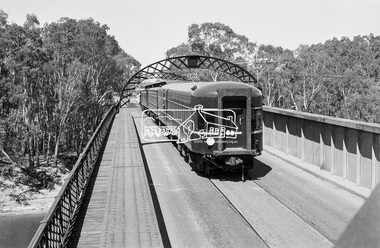 Eltham District Historical Society Inc
Photograph, VR Commissioner's Special train, steam locomotive D3-639 crossing the Echuca-Moama Road Rail Bridge over the Murray River from Moama, NSW to Echuca, Victoria, 1962
... crossing the Echuca-Moama Road Rail Bridge over the Murray River... Bridge over the Murray River from Moama, NSW to Echuca, Victoria ...Looking south into Echuca, VictoriaDigital TIFF file Scan of 35mm Ilford FP3 black and white negative transparencyd3-639, d3-class steam locomotive, echuca-moama road rail bridge, george coop collection, murray river, vr commissioner's special train